Ring Of Fire Is Becoming More Active - Are We Prepared For What Could Come Next?
 By Michael Snyder/End of the American Dream May 03, 2025
Share this article:
In recent months, we have seen a tremendous amount of seismic activity occur along the Ring of Fire. Sizable earthquakes have been popping off like firecrackers, and volcanic activity has risen to very alarming levels. If you doubt this, just check out the eruption map on volcanodiscovery.com.
As you can see from that map, volcanoes are erupting all around the perimeter of the Pacific Ocean. Of course this shouldn't exactly shock any of us, because 75 percent of all of the active volcanoes in the world are located along the Ring of Fire...
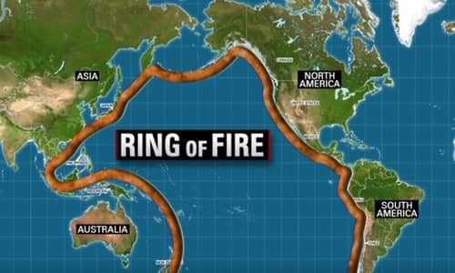
Most people are shocked to learn that the Ring of Fire isn't an actual "ring" you can see, but a massive horseshoe-shaped belt stretching over 40,000 kilometers around the Pacific Ocean. This region touches the coasts of North and South America, Asia, and Oceania.
It's home to 75% of the world's active volcanoes--over 450 in total. The numbers are staggering: about 90% of all earthquakes on Earth occur here each year.
For decades, the west coast of the United States has been one of the quietest stretches of the Ring of Fire.
But now that is changing.
A couple of weeks ago, there was a magnitude 5.2 earthquake near San Diego, and the region has been rattled by literally hundreds of small earthquakes within the past 7 days.
The good news is that we haven't seen a cataclysmic west coast earthquake yet, but one of these days time will finally run out.
This week, we learned that a team of researchers has determined that a large enough earthquake along the Cascadia Subduction Zone could cause the ground "to suddenly sink" in coastal areas of northern California, Oregon and Washington state...
Researchers warn that a "megaquake" -- an exceptionally large earthquake with a magnitude of 8.0 or higher -- along the Cascadia Subduction Zone could cause the ground in some areas to suddenly sink. The Cascadia Subduction Zone is a fault line that stretches from Northern California to British Columbia. This abrupt sinking, known as "sudden coastal subsidence," would immediately raise local sea levels, inundate floodplains and leave entire coastal communities dangerously exposed to flooding.
So how much could some of these coastal areas sink?
Well, we are being told that a magnitude 8.0 earthquake could cause the ground to fall by up to six and a half feet in just 30 minutes...
A 700-mile-long fault line that runs along the West Coast is overdue for a massive earthquake that scientists warn could sink parts of the US.
New research found that a 8.0 magnitude or higher quake along the Cascadia Subduction Zone, combined with rising sea levels, would cause coastal land to sink up to 6.5 feet within 30 minutes of a major tremor.
Wow.
That would be quite dramatic.
The lead author of the study says that once this occurs, "all the sea level rise you expected by 2300 is going to happen in minutes"...
In such events, "all the sea level rise you expected by 2300 is going to happen in minutes," Tina Dura, the study's lead author and assistant professor of geosciences at Virginia Tech told the San Francisco Chronicle.
What do you think that would mean for the millions of people that live near the coast in northern California, Oregon and Washington state?
Needless to say, a lot of "oceanfront property" would suddenly be under the Pacific Ocean permanently.
I was curious, and so I asked Google AI if a similar thing could happen in southern California, and this is what I was told...
Yes, land east of the San Andreas Fault could experience significant subsidence, meaning the ground could sink by several feet, during a major earthquake. The San Andreas Fault is a strike-slip fault, where the Pacific Plate slides past the North American Plate. This movement can cause the ground to shift and drop, especially during earthquakes.
Because there have been so many earthquakes in southern California in 2025, there has been a lot of talk about "the Big One" recently. For example, the following comes from an article that was posted by Newsweek earlier this year...
Seismologists are closely monitoring California's fault lines as concerns grow about the possibility that the "Big One" could happen soon.
The "Big One" refers to a massive earthquake that could occur along the San Andreas Fault, one of the state's most significant and active fault lines. Scientists predict that this earthquake could reach a magnitude of 7.8 or higher, causing widespread destruction across Southern California or the San Francisco Bay Area depending on the rupture location.
I am convinced that when "the Big One" arrives, it will be far larger than magnitude 7.8. In my new book entitled "10 Prophetic Events That Are Coming Next", I talk about a cataclysmic earthquake that will radically alter the geography of the California coast. Once that apocalyptic quake occurs, you won't want to be living anywhere in the state of California.
Of course the entire southern coast of Alaska also sits directly along the Ring of Fire, and there have been signs that Mount Spurr could erupt very soon.
In fact, Mount Spurr has been getting rattled by dozens of significant earthquakes in recent days...
Mount Spurr in Alaska has experienced 66 earthquakes in just one week, signaling increased instability around the volcano.
The Alaska Volcano Observatory (AVO) released a report late last week detailing the heightened seismic activity, noting that an eruption cannot be ruled out.
If it erupts, it could send volcanic ash tens of thousands of feet into the air.
That would certainly cause quite a bit of chaos for all of the air traffic that comes through that region...
A massive cloud of ash billowing 50,000 feet into the air would force international hubs such as Ted Stevens Anchorage International Airport (ANC) and potentially Fairbanks International Airport (FAI) to shut down.
Halting all incoming and departing flights at these airports could have a ripple effect across the country, resulting in widespread delays and cancellations and even disrupting the global supply chain.
Hundreds of planes fly over Anchorage and Fairbanks per day, and it's not just passenger flights that would be impacted. ANC is the fourth-busiest cargo airport in the world, with more than 8,000 cargo flights passing through each month.
Let us hope that Mount Spurr does not erupt any time soon.
But whether that happens or not, without a doubt our planet has entered a time of increasing instability.
Tectonic plates are constantly shifting and moving, and scientists assure us that cataclysmic natural disasters are inevitable.
If you live on the west coast of the United States, you are living in one of the world's worst danger zones, and I would encourage you to make preparations for what is coming while you still can.
Originally published at End Of The American Dream